

Last weekend we were supposed to head north to a cabin in the woods but the weather had other ideas. So with snow in the forecast, we loaded up the car and headed south to Vicksburg. I was in search of Airlie.

KCB was born and raised on a plantation called Airlie. Just like with Hazelwood, I don’t remember when I first saw the name Airlie. At this point, it just seems like I’ve always known that KCB was born and raised on a plantation called Airlie. Through census records, I found out that Airlie was located in Carroll Parish, Louisiana – now East Carroll Parish. That’s northeastern Louisiana, right on the Arkansas border. Unlike my search for Hazelwood, I knew more about this geography. In doing research on Carroll Parish, I came across place names like Lake Providence, Transylvania, and Tallulah. These were familiar to me from the long drive to and from the Redneck Riviera (the beaches along the Mississippi, Alabama and Florida Gulf coast). One time I even stopped at the Louisiana Cotton Museum outside Lake Providence to ask if they knew anything about the Carsons or a plantation called Airlie. I went in. I asked. They said no. I left.
Pretty early on I discovered the Airlie Plantations Records. They are part of a huge collection of plantation records – collected and housed a various archives and special collections around the United States. The Airlie Plantation records are part of the collection at the University of Texas at Austin. Thankfully the collection has been microfilmed.
I ordered the microfilm. After several misfires (asking for the wrong series or the wrong reel), I had the right film in hand. The Airlie collection was assembled by Robert C. Reinders in the early 1950s. Dr. Reinders was associated with St. Edward’s University in Austin, Texas (now part of the University of Texas at Austin). The plantation records were interesting and insightful (more on that later) but the real find was a map marking the location of Airlie. This was all I needed for my thesis – a general idea of where it was. Below Lake Providence and Transylvania on the Mississippi River.
I didn’t need to know everything else – geographically speaking – about Airlie. I could find everything else I needed – information about plantation society in northeastern Louisiana – from other secondary sources. I wasn’t doing a history of the plantation. Just the girl who grew up there. I’m a firm believer that place makes a person but you can’t research forever. At some point, you have to shut the book and write.
Katherine Carson Breckinridge’s early life on her father’s plantations along the Mississippi River and the Carsons’ home life resembled that of other planter families in the region. The family grew in size and wealth between 1846 and 1860. J. H. McNeilly estimated that Carson owned between four and five hundred slaves in 1862, including two hundred and fifty inherited upon the death of James Railey.
McNeilly, a visitor to Airlie Plantation in 1862, wrote a description of the Carson family, their home, their personal characteristics, and his experiences during his visit. McNeilly described the house as “a rambling one story frame building with many rooms, which had been added as occasion demanded.” He noted that the family consisted of Dr. and Mrs. Carson, their five children, and “a gentleman from New York, who taught the boys.”
segment from thesis about Airlie including quotes from McNeilly sketch, part of the Breckinridge Family Papers at the Library of Congress
As the years went by, I started to wonder more and more about Airlie. Where it was exactly? What did it look like? Was anything else left? What was life like there?

So I ordered the Airlie Plantation Records microfilm again (and again ordered the wrong reel at first!) I looked a little longer! I examined it a little closer. Have you used microfilm lately? It’s almost an enjoyable experience! You load the film, advance to the frame you want, and scan it to a flash drive! BRILLIANT! If it had been that easy before I might have used it more!
The papers were more extensive than I remember. Or more extensive than I bothered to scroll through looking for what I didn’t know I was looking for. Included with the papers was Dr. Reinders’ correspondence with people who remembered the Carsons and were still living in Carroll Parish in the early 1950s. I’d just fast-scrolled through this before. But now with a closer look…
We were about four miles form Airlie which I remember as being a big, comfortable house, set well back from the public road, running along the base of the levee. It was reached by a tree-lined avenue. I was taken there to play with a little girl named Agnes Green, whose mother lived with Mrs. Savage. I indefinitely recall an attractive young lady, Lily Scanlan. These people were from the North, were lively and entertained elaborately.
Mrs. Minnie Murphy, Tallulah, Louisiana, May 7, 1951
On a closer read of Kate Stone’s Brokenburn: The Journal of Kate Stone, 1861-1868, Stone describes Airlie as

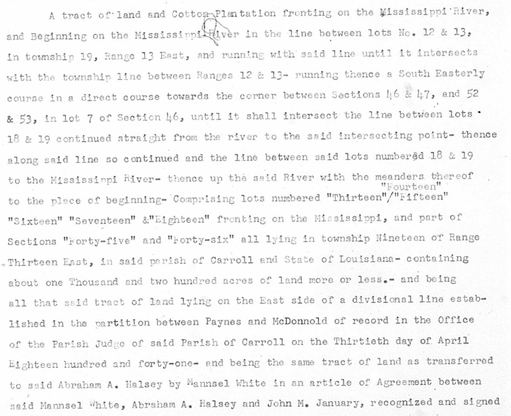
But I wanted to find where it was. In the plantation records collected by Dr. Reinders was a typed copy of the deed of sale. And in that typed deed, I found the township and range coordinates for Airlie.
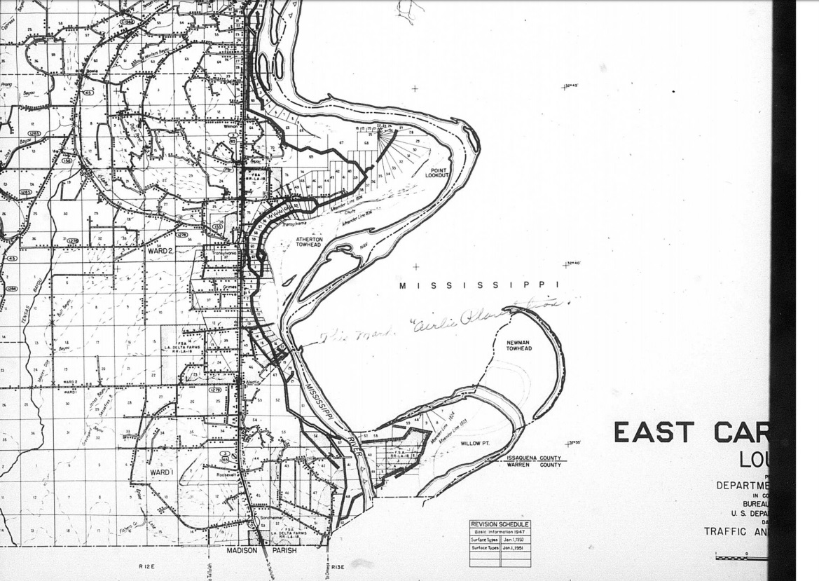
About the same time last year, I was searching the internet for plantation maps of Carroll Parish and the surrounding parishes (as well as the counties across the river in Mississippi). I found lots of beautiful maps showing the lower Louisiana plantations – the famous ones along the Great River Road between New Orleans and Baton Rouge. And then I spotted this map on the Library of Congress website.
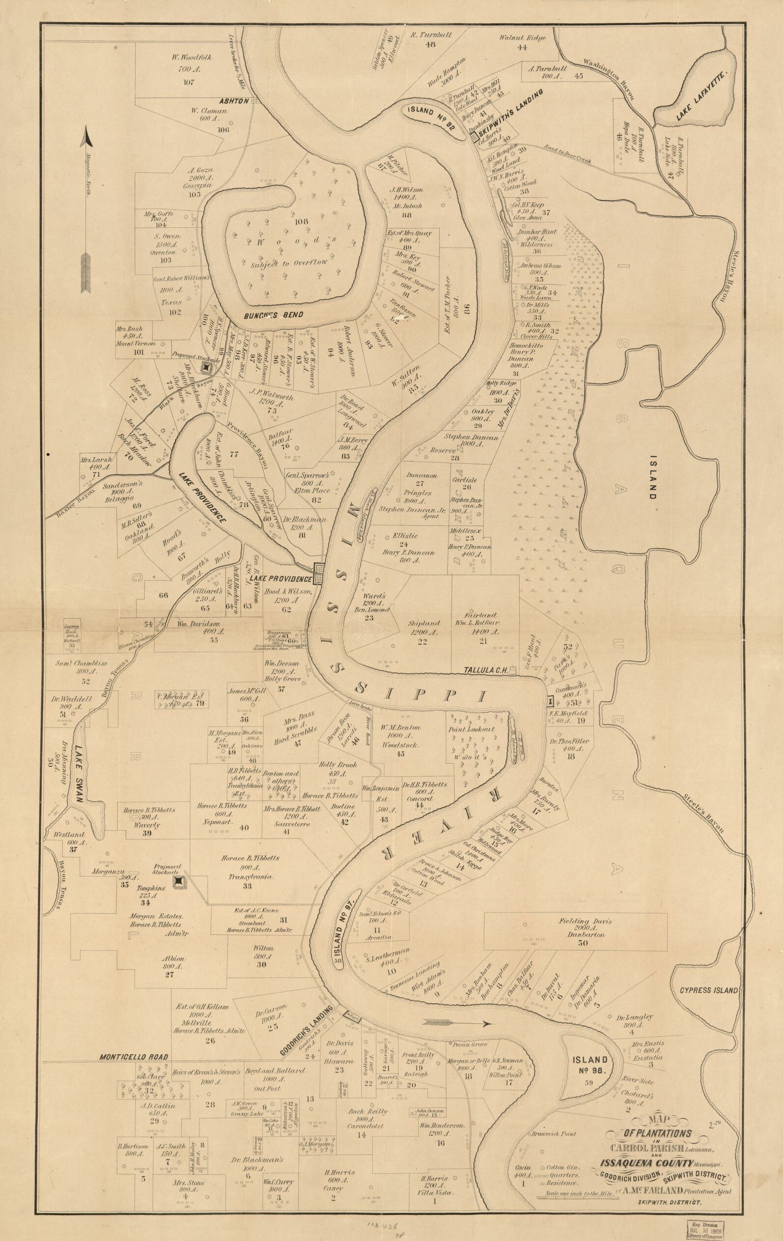
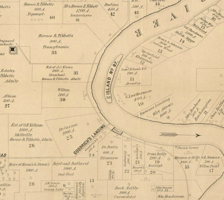
This was an exciting day because there – just above Goodrich’s Landing – is Airlie Plantation. It’s not labeled Airlie (some of the other plantations are listed by their owner’s name and their place name) but it is labeled
Dr. Carson 1000 A
I compared this map to other maps I have been looking at.
And look what I discovered.

I found this map on a website talking about Kate Stone. So there’s Brokenburn in red and just above it is Pecan Grove (the Carsons’ postal address) and just above Pecan Grove is REILY. Now wait a minute… James Green Carson’s guardian was named Railey. But could it be that it was really Reily? Is this one of those cases where the person says their name and the person writing it down spells it however they want to spell it?

Here in 1848, it’s Dr. James Carson. Same on the 1853 map from the same makers.

And then here … at number 540 on the river… Reilly. And this is postwar – 1866.
Ok back to searching for Airlie. With more time – no pressure of getting my thesis done and the help of my husband who looks at things differently and knows a lot about maps – I’m able to piece it all together. Place names on maps start to come up over and over. Taking the time to read Kate Stone’s diary in detail and not just skim for Carsons, a picture of the neighborhood starts to form.
Way back in high school – in geology class – the teacher taught us how to use topo maps and how to find a specific tract of land by using township and range coordinates. It’s one of the many things I’m so glad I know. I went to the township maps for Louisiana. Found the map for East Carroll Parish.

And right there, at Township 19 N, Range 13 E, Sections 12 &13 is the land James Green Carson bought from Mansel, White, and January in 1846. The “tract of land and Cotton Plantation” from the 1846 deed. It is the property he lived on until 1863 when the family escaped the advancing Union troops and fled to Texas. It was where KCB was born and where she grew up.
So when my husband suggested we head south to Vicksburg, I knew we’d be looking for Airlie. Well at least I would be. And just past Transylvania but not quite to Alastia on Highway 65 in northeastern Louisiana is Parish Road 2208 (although the road sign says Bunge). Turn east toward the levee and the River. Past two farms – one on each side. Up the levee.


There it is. The place where Airlie once stood.
In reality, the land where the house stood is probably under the muddy water of the Mississippi. The river has changed course many times since 1860. And the levee there today – the one designed by the Corps of Engineers to control the powerful artery – is built higher than the levee from 1844 or 1848. But this is it. Her home. The place she grew up. The place that shaped her.
Now I’m on a mission to discover everything I can about Carroll Parish plantations, the neighbors who lived around them, and the landscape that shaped the society of the antebellum period. It’s just the tip of the iceberg!

I would love to exchange information about other plantations in East Carroll Parish, Louisiana. I am researching Goodrich Landing Plantation once owned by Henry Goodrich. It would have been located in the area near Transylvania.
LikeLike
Hi! Just email me at museumgirlknitz@gmail.com. Goodrich Landing was right next “door” to Airlie. There is a pre-war map showing the plantations in Carroll Parish and lists the names of the landowners (https://www.loc.gov/item/2012592308/).
LikeLike